
Tycho
43.30° S · 11.22° W
Catalogue dimension: 85.3 km
Look for the rim and shadows near the terminator. Return under different lighting to compare the floor and terrain.
From vast maria to narrow rilles: choose a feature, locate it and keep a record of your observation.
An educational selection by the portal to discover over several lunar cycles. Check off only what you have actually identified. Objects near the limb and narrow rilles are more demanding.
0 / 100 features observed
Progress is stored only in this browser, on this site. Export a backup before changing devices or clearing browser data. Importing merges observations; existing entries are retained in a conflict.
The LRO photographic mosaic shows the near side, north up. Feature centres are projected onto the lunar disc; dots do not represent their sizes. This reference background reproduces neither today’s phase nor libration.
Photographic background: NASA/Goddard/Arizona State University · Lunar Reconnaissance Orbiter. The near side is extracted for display from the mosaic of both hemispheres. Approximate positions, orthographic projection centred on 0° N / 0° E. Mosaic source
When zoomed in, scroll the map horizontally and vertically. Click a dot to open its fact sheet. The filters below also apply to the map.
Open the LROC QuickMap photographic map ↗ · NASA daily lunar guide ↗
Mission layer: 13 documented near-side sites. Discover missions and far-side sites →
100 features
43.30° S · 11.22° W
Catalogue dimension: 85.3 km
Look for the rim and shadows near the terminator. Return under different lighting to compare the floor and terrain.
9.62° N · 20.08° W
Catalogue dimension: 96.1 km
Look for the rim and shadows near the terminator. Return under different lighting to compare the floor and terrain.
8.12° N · 38.01° W
Catalogue dimension: 29.5 km
Look for the rim and shadows near the terminator. Return under different lighting to compare the floor and terrain.
23.73° N · 47.49° W
Catalogue dimension: 40 km
Look for the rim and shadows near the terminator. Return under different lighting to compare the floor and terrain.
51.62° N · 9.38° W
Catalogue dimension: 100.7 km
Look for the rim and shadows near the terminator. Return under different lighting to compare the floor and terrain.
58.62° S · 14.73° W
Catalogue dimension: 230.8 km
Look for the rim and shadows near the terminator. Return under different lighting to compare the floor and terrain.
9.16° S · 1.84° W
Catalogue dimension: 153.7 km
Look for the rim and shadows near the terminator. Return under different lighting to compare the floor and terrain.
13.39° S · 2.85° W
Catalogue dimension: 110.5 km
Look for the rim and shadows near the terminator. Return under different lighting to compare the floor and terrain.
18.26° S · 1.93° W
Catalogue dimension: 97 km
Look for the rim and shadows near the terminator. Return under different lighting to compare the floor and terrain.
14.47° N · 11.32° W
Catalogue dimension: 58.8 km
Look for the rim and shadows near the terminator. Return under different lighting to compare the floor and terrain.
29.72° N · 3.99° W
Catalogue dimension: 81 km
Look for the rim and shadows near the terminator. Return under different lighting to compare the floor and terrain.
33.88° N · 1.21° E
Catalogue dimension: 54.4 km
Look for the rim and shadows near the terminator. Return under different lighting to compare the floor and terrain.
30.68° N · 1.49° E
Catalogue dimension: 38.9 km
Look for the rim and shadows near the terminator. Return under different lighting to compare the floor and terrain.
40.25° N · 4.64° E
Catalogue dimension: 56.9 km
Look for the rim and shadows near the terminator. Return under different lighting to compare the floor and terrain.
50.24° N · 17.32° E
Catalogue dimension: 87.6 km
Look for the rim and shadows near the terminator. Return under different lighting to compare the floor and terrain.
44.27° N · 16.23° E
Catalogue dimension: 70.2 km
Look for the rim and shadows near the terminator. Return under different lighting to compare the floor and terrain.
31.88° N · 29.99° E
Catalogue dimension: 95.1 km
Look for the rim and shadows near the terminator. Return under different lighting to compare the floor and terrain.
11.45° S · 26.28° E
Catalogue dimension: 98.6 km
Look for the rim and shadows near the terminator. Return under different lighting to compare the floor and terrain.
13.29° S · 24.07° E
Catalogue dimension: 98.1 km
Look for the rim and shadows near the terminator. Return under different lighting to compare the floor and terrain.
17.98° S · 23.55° E
Catalogue dimension: 98.8 km
Look for the rim and shadows near the terminator. Return under different lighting to compare the floor and terrain.
14.57° N · 54.72° E
Catalogue dimension: 22.3 km
Look for the rim and shadows near the terminator. Return under different lighting to compare the floor and terrain.
16.09° N · 46.89° E
Catalogue dimension: 26.9 km
Look for the rim and shadows near the terminator. Return under different lighting to compare the floor and terrain.
8.86° S · 61.04° E
Catalogue dimension: 132 km
Look for the rim and shadows near the terminator. Return under different lighting to compare the floor and terrain.
25.39° S · 60.78° E
Catalogue dimension: 184.1 km
Look for the rim and shadows near the terminator. Return under different lighting to compare the floor and terrain.
16.46° S · 61.55° E
Catalogue dimension: 141.2 km
Look for the rim and shadows near the terminator. Return under different lighting to compare the floor and terrain.
36.00° S · 60.54° E
Catalogue dimension: 135 km
Look for the rim and shadows near the terminator. Return under different lighting to compare the floor and terrain.
17.55° S · 39.96° W
Catalogue dimension: 111.4 km
Look for the rim and shadows near the terminator. Return under different lighting to compare the floor and terrain.
44.38° S · 55.11° W
Catalogue dimension: 212.2 km
Look for the rim and shadows near the terminator. Return under different lighting to compare the floor and terrain.
49.53° S · 60.44° W
Catalogue dimension: 84.7 km
Look for the rim and shadows near the terminator. Return under different lighting to compare the floor and terrain.
51.72° S · 39.78° W
Catalogue dimension: 179.4 km
Look for the rim and shadows near the terminator. Return under different lighting to compare the floor and terrain.
66.82° S · 68.90° W
Catalogue dimension: 300.6 km
Look for the rim and shadows near the terminator. Return under different lighting to compare the floor and terrain.
5.38° S · 68.36° W
Catalogue dimension: 235 km
Look for the rim and shadows near the terminator. Return under different lighting to compare the floor and terrain.
2.90° S · 74.42° W
Catalogue dimension: 155.7 km
Look for the rim and shadows near the terminator. Return under different lighting to compare the floor and terrain.
2.20° N · 67.46° W
Catalogue dimension: 113.9 km
Look for the rim and shadows near the terminator. Return under different lighting to compare the floor and terrain.
5.10° N · 66.93° W
Catalogue dimension: 59.3 km
Look for the rim and shadows near the terminator. Return under different lighting to compare the floor and terrain.
6.92° N · 54.98° W
Catalogue dimension: 29.8 km
Look for the rim and shadows near the terminator. Return under different lighting to compare the floor and terrain.
11.90° N · 50.84° W
Catalogue dimension: 40.1 km
Look for the rim and shadows near the terminator. Return under different lighting to compare the floor and terrain.
23.25° N · 49.84° W
Catalogue dimension: 35.9 km
Look for the rim and shadows near the terminator. Return under different lighting to compare the floor and terrain.
11.57° S · 14.19° W
Catalogue dimension: 60.8 km
Look for the rim and shadows near the terminator. Return under different lighting to compare the floor and terrain.
6.06° S · 16.97° W
Catalogue dimension: 96.8 km
Look for the rim and shadows near the terminator. Return under different lighting to compare the floor and terrain.
8.38° S · 17.33° W
Catalogue dimension: 59.2 km
Look for the rim and shadows near the terminator. Return under different lighting to compare the floor and terrain.
7.88° S · 15.78° W
Catalogue dimension: 47.3 km
Look for the rim and shadows near the terminator. Return under different lighting to compare the floor and terrain.
16.05° S · 4.51° W
Catalogue dimension: 40 km
Look for the rim and shadows near the terminator. Return under different lighting to compare the floor and terrain.
5.69° S · 2.09° W
Catalogue dimension: 39.1 km
Look for the rim and shadows near the terminator. Return under different lighting to compare the floor and terrain.
5.36° S · 4.91° E
Catalogue dimension: 143.9 km
Look for the rim and shadows near the terminator. Return under different lighting to compare the floor and terrain.
11.24° S · 4.01° E
Catalogue dimension: 130.8 km
Look for the rim and shadows near the terminator. Return under different lighting to compare the floor and terrain.
25.51° S · 2.03° W
Catalogue dimension: 115 km
Look for the rim and shadows near the terminator. Return under different lighting to compare the floor and terrain.
28.28° S · 1.09° W
Catalogue dimension: 126.6 km
Look for the rim and shadows near the terminator. Return under different lighting to compare the floor and terrain.
28.04° N · 33.81° W
Catalogue dimension: 1.3 km
Look for the rim and shadows near the terminator. Return under different lighting to compare the floor and terrain.
41.24° S · 5.93° E
Catalogue dimension: 129.9 km
Look for the rim and shadows near the terminator. Return under different lighting to compare the floor and terrain.
41.77° S · 13.92° E
Catalogue dimension: 115.3 km
Look for the rim and shadows near the terminator. Return under different lighting to compare the floor and terrain.
50.03° S · 5.98° W
Catalogue dimension: 155.6 km
Look for the rim and shadows near the terminator. Return under different lighting to compare the floor and terrain.
70.63° S · 5.95° W
Catalogue dimension: 114.4 km
Look for the rim and shadows near the terminator. Return under different lighting to compare the floor and terrain.
76.64° S · 24.69° E
Catalogue dimension: 85.8 km
Look for the rim and shadows near the terminator. Return under different lighting to compare the floor and terrain.
76.52° S · 17.44° W
Catalogue dimension: 83.9 km
Look for the rim and shadows near the terminator. Return under different lighting to compare the floor and terrain.
49.55° S · 21.88° W
Catalogue dimension: 145.5 km
Look for the rim and shadows near the terminator. Return under different lighting to compare the floor and terrain.
37.10° S · 47.17° E
Catalogue dimension: 70.8 km
Look for the rim and shadows near the terminator. Return under different lighting to compare the floor and terrain.
44.96° S · 40.82° E
Catalogue dimension: 200.7 km
Look for the rim and shadows near the terminator. Return under different lighting to compare the floor and terrain.
42.75° S · 41.84° E
Catalogue dimension: 78.9 km
Look for the rim and shadows near the terminator. Return under different lighting to compare the floor and terrain.
40.42° S · 43.37° E
Catalogue dimension: 83.8 km
Look for the rim and shadows near the terminator. Return under different lighting to compare the floor and terrain.
45.07° N · 28.21° E
Catalogue dimension: 41 km
Look for the rim and shadows near the terminator. Return under different lighting to compare the floor and terrain.
45.13° N · 27.32° E
Catalogue dimension: 158.8 km
Compare the outline of this dark plain with the surrounding terrain. A mostly illuminated Moon helps identify large regions, even when shadows are less pronounced.
46.74° N · 44.38° E
Catalogue dimension: 88.1 km
Look for the rim and shadows near the terminator. Return under different lighting to compare the floor and terrain.
46.82° N · 39.21° E
Catalogue dimension: 68.3 km
Look for the rim and shadows near the terminator. Return under different lighting to compare the floor and terrain.
53.61° N · 56.48° E
Catalogue dimension: 122.1 km
Look for the rim and shadows near the terminator. Return under different lighting to compare the floor and terrain.
27.60° N · 55.50° E
Catalogue dimension: 130.8 km
Look for the rim and shadows near the terminator. Return under different lighting to compare the floor and terrain.
34.42° N · 56.66° E
Catalogue dimension: 82 km
Look for the rim and shadows near the terminator. Return under different lighting to compare the floor and terrain.
39.31° N · 60.06° E
Catalogue dimension: 122.4 km
Look for the rim and shadows near the terminator. Return under different lighting to compare the floor and terrain.
38.73° N · 47.64° E
Catalogue dimension: 55.9 km
Look for the rim and shadows near the terminator. Return under different lighting to compare the floor and terrain.
40.68° N · 45.78° E
Catalogue dimension: 39.4 km
Look for the rim and shadows near the terminator. Return under different lighting to compare the floor and terrain.
34.72° N · 14.91° W
Catalogue dimension: 1145.5 km
Compare the outline of this dark plain with the surrounding terrain. A mostly illuminated Moon helps identify large regions, even when shadows are less pronounced.
20.67° N · 56.68° W
Catalogue dimension: 2592.2 km
Compare the outline of this dark plain with the surrounding terrain. A mostly illuminated Moon helps identify large regions, even when shadows are less pronounced.
27.29° N · 18.36° E
Catalogue dimension: 674.3 km
Compare the outline of this dark plain with the surrounding terrain. A mostly illuminated Moon helps identify large regions, even when shadows are less pronounced.
8.35° N · 30.83° E
Catalogue dimension: 875.7 km
Compare the outline of this dark plain with the surrounding terrain. A mostly illuminated Moon helps identify large regions, even when shadows are less pronounced.
16.18° N · 59.10° E
Catalogue dimension: 555.9 km
Compare the outline of this dark plain with the surrounding terrain. A mostly illuminated Moon helps identify large regions, even when shadows are less pronounced.
7.83° S · 53.67° E
Catalogue dimension: 840.4 km
Compare the outline of this dark plain with the surrounding terrain. A mostly illuminated Moon helps identify large regions, even when shadows are less pronounced.
15.19° S · 34.60° E
Catalogue dimension: 339.4 km
Compare the outline of this dark plain with the surrounding terrain. A mostly illuminated Moon helps identify large regions, even when shadows are less pronounced.
20.59° S · 17.29° W
Catalogue dimension: 714.5 km
Compare the outline of this dark plain with the surrounding terrain. A mostly illuminated Moon helps identify large regions, even when shadows are less pronounced.
24.48° S · 38.57° W
Catalogue dimension: 419.7 km
Compare the outline of this dark plain with the surrounding terrain. A mostly illuminated Moon helps identify large regions, even when shadows are less pronounced.
57.59° N · 0.01° W
Catalogue dimension: 1446.4 km
Compare the outline of this dark plain with the surrounding terrain. A mostly illuminated Moon helps identify large regions, even when shadows are less pronounced.
13.20° N · 4.09° E
Catalogue dimension: 242.5 km
Compare the outline of this dark plain with the surrounding terrain. A mostly illuminated Moon helps identify large regions, even when shadows are less pronounced.
10.53° S · 22.31° W
Catalogue dimension: 350 km
Compare the outline of this dark plain with the surrounding terrain. A mostly illuminated Moon helps identify large regions, even when shadows are less pronounced.
7.79° N · 30.64° W
Catalogue dimension: 511.9 km
Compare the outline of this dark plain with the surrounding terrain. A mostly illuminated Moon helps identify large regions, even when shadows are less pronounced.
45.01° N · 31.67° W
Catalogue dimension: 249.3 km
Compare the outline of this dark plain with the surrounding terrain. A mostly illuminated Moon helps identify large regions, even when shadows are less pronounced.
1.63° N · 1.03° E
Catalogue dimension: 286.7 km
Compare the outline of this dark plain with the surrounding terrain. A mostly illuminated Moon helps identify large regions, even when shadows are less pronounced.
50.26° N · 50.86° W
Catalogue dimension: 195 km
Compare the outline of this dark plain with the surrounding terrain. A mostly illuminated Moon helps identify large regions, even when shadows are less pronounced.
27.36° N · 0.00° E
Catalogue dimension: 180.5 km
Compare the outline of this dark plain with the surrounding terrain. A mostly illuminated Moon helps identify large regions, even when shadows are less pronounced.
37.56° N · 30.80° E
Catalogue dimension: 424.8 km
Compare the outline of this dark plain with the surrounding terrain. A mostly illuminated Moon helps identify large regions, even when shadows are less pronounced.
19.87° N · 0.03° E
Catalogue dimension: 599.7 km
Follow the shadows of the peaks when the light is low. Compare the range with the neighbouring plains.
48.36° N · 0.58° W
Catalogue dimension: 334.5 km
Follow the shadows of the peaks when the light is low. Compare the range with the neighbouring plains.
37.52° N · 9.93° E
Catalogue dimension: 443.5 km
Follow the shadows of the peaks when the light is low. Compare the range with the neighbouring plains.
14.57° N · 23.62° W
Catalogue dimension: 333.6 km
Follow the shadows of the peaks when the light is low. Compare the range with the neighbouring plains.
47.49° N · 36.11° W
Catalogue dimension: 420.8 km
Follow the shadows of the peaks when the light is low. Compare the range with the neighbouring plains.
17.11° N · 12.03° E
Catalogue dimension: 384.7 km
Follow the shadows of the peaks when the light is low. Compare the range with the neighbouring plains.
7.48° S · 27.60° W
Catalogue dimension: 190.1 km
Follow the shadows of the peaks when the light is low. Compare the range with the neighbouring plains.
49.21° N · 3.63° E
Catalogue dimension: 155.4 km
Find the valley’s edges under low-angle lighting; fine details require good conditions.
21.67° S · 7.70° W
Catalogue dimension: 115.9 km
Look for the shadow line or bright line, depending on the direction of illumination. A feature’s appearance can change greatly between lunar morning and evening.
24.32° S · 23.12° E
Catalogue dimension: 545.2 km
Look for the shadow line or bright line, depending on the direction of illumination. A feature’s appearance can change greatly between lunar morning and evening.
7.62° N · 6.77° E
Catalogue dimension: 204 km
This rille requires steady air and low-angle lighting. First locate the large features nearby.
6.48° N · 13.44° E
Catalogue dimension: 247.4 km
This rille requires steady air and low-angle lighting. First locate the large features nearby.
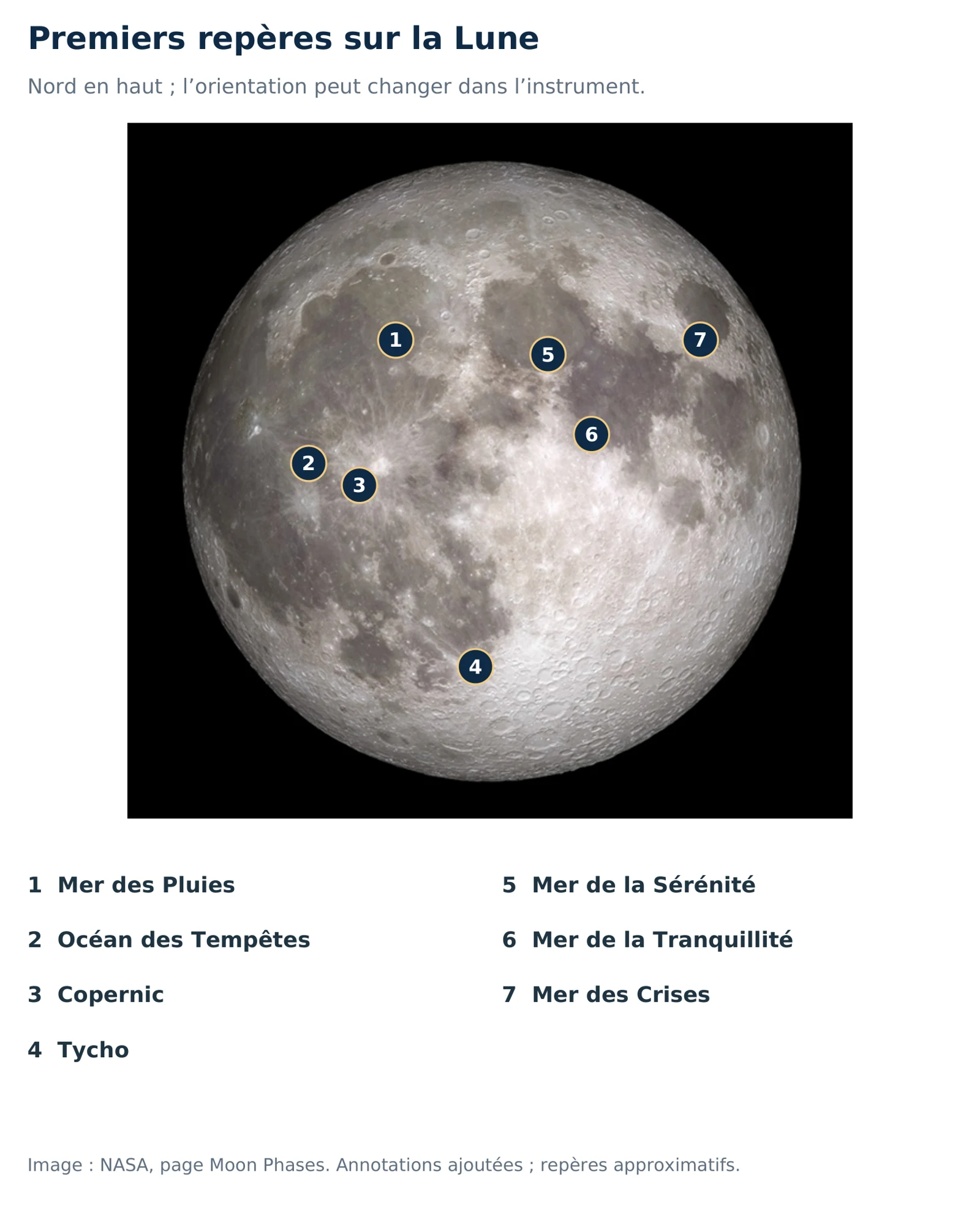
Names follow the official nomenclature. Latitude is positive northwards; longitude is expressed east or west of the central meridian. Dimensions come from the catalogue: they do not indicate the terrain’s height and do not represent a crater diameter for other feature types.
This selection covers the near side. Actual visibility depends on phase, libration, the instrument and atmospheric turbulence. Near the terminator, shadows often help reveal terrain; more direct lighting better reveals some contrasts and rays. The advice is general and does not predict visibility.
Data: Gazetteer of Planetary Nomenclature, IAU/USGS, extracted on 18 October 2026, LOLA 2011 reference system. Coordinates are displayed to two decimal places, dimensions rounded to one tenth of a kilometre. Each fact sheet links to its official source.
Adapted from the “La Lune” chapter of Steve Cimolino’s volume II, Comprendre comment explorer le ciel, manuscript dated 17 October 2026. The plates come from the book and have been resized for the web.
Photographs of both sides: NASA/Goddard/Arizona State University (LRO), Synchronous rotation. Annotated map: NASA photograph, Moon Phases, book annotations and approximate markers. Phase diagram: educational plate from volume II. NASA image use guidelines.
To explore further: NASA observing advice · Craters and maria · Lunar eclipses.
Discover volume II →